We got a call a few winters ago about a proposed mid-rise on Hurontario Street where three previous boreholes had hit refusal at wildly different depths, between 4 and 11 meters. The developer needed a continuous profile between the boreholes without bringing a drill rig back onto a tight site with frozen service lines. That is exactly the kind of problem where electrical resistivity fills the gap. An 80-meter VES spread run parallel to the sidewalk mapped the shale bedrock surface within half a meter, confirmed by a single check borehole. In Mississauga, where the overburden is a messy stack of Halton Till, glaciolacustrine silts, and occasional sand lenses from the old Lake Iroquois shoreline, point data from boreholes alone can mislead you badly. The resistivity contrast between saturated clay-rich till and the Georgian Bay shale is stark: till sits around 20 to 40 ohm-m, while competent shale jumps above 80 ohm-m. We run the survey, invert the apparent resistivity curve with a least-squares routine, and hand over a 1D geoelectric model you can correlate directly with borehole logs. For deeper targets or mapping lateral changes across a larger footprint, we often combine VES soundings with a few MASW lines to tie shear-wave velocity to the resistivity stratigraphy, giving you both stiffness and material type before a single excavator bucket hits the ground.
A single VES sounding across the overburden-bedrock interface can eliminate two or three unnecessary boreholes on a Mississauga site.
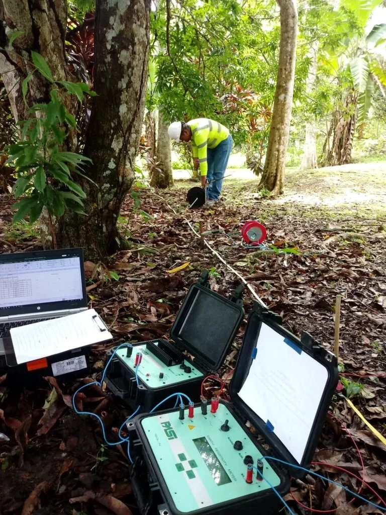
How we work
The near-surface geology across most of Mississauga is a product of the Wisconsin glaciation and the post-glacial Lake Iroquois phase. In the city center and toward the airport, you get stiff to hard silty clay till with a desiccated crust that can fool shallow resistivity readings if you don't compensate for seasonal moisture changes. Down toward the Credit River valley, the section gets more complicated: outwash sands and gravels interbedded with glaciolacustrine rhythmites create low-resistivity traps that can mask the true bedrock depth if the array spacing is too coarse. We use a Schlumberger array for most urban lots because it gives good vertical resolution with fewer electrode moves, and we keep the AB/2 expansion tight enough to catch thin sand seams. A typical sounding in Mississauga reaches 30 to 50 meters depth, enough to see through the drift and well into the shale. Data quality matters: we measure at each expansion step until the standard deviation drops below 2%, rejecting noisy readings from buried utilities or induced polarization in organic fills. The final geoelectric section gives you a clean model with layer resistivities, thicknesses, and an interpreted geological log that reads like a borehole without the drilling.
Site-specific factors
Mississauga's build-out from a bedroom community of Toronto into a standalone city with dense high-rise clusters around Square One and the Cooksville node happened fast, and a lot of the older geotechnical records are scattered across half a dozen consulting firms or simply lost. We have pulled up borehole logs from the 1970s that show bedrock at 6 meters, then drilled the same lot and found it at 9 meters, because the original driller logged a large boulder as shale. That kind of error, if carried into foundation design, turns into a change order when the excavator hits real rock two meters deeper than expected. Resistivity soundings catch that mismatch early. Another risk specific to the area is perched groundwater in sand lenses within the till, which reads as a conductive layer and can be mistaken for clay. We flag that in the interpretation and recommend a piezometer or a CPT sounding to confirm. The cost of skipping a geophysical cross-check is not theoretical, we have seen it on City Centre Drive and Burnhamthorpe Road projects where redesigns after unexpected ground conditions ran into five figures.
Regulatory framework
ASTM D6431-18 (Standard Guide for Using the Direct Current Resistivity Method for Subsurface Site Characterization), NBCC 2020 Part 4 (Structural Design, Section 4.2.4 Geotechnical Considerations), CSA A23.3-19 (Design of Concrete Structures, referenced for foundation design integration with geophysical data), Ontario Regulation 903 (Water Wells, relevant for resistivity-based groundwater exploration)
Frequently asked questions
What depth can a VES survey reach in Mississauga soils?
With a Schlumberger array and maximum AB/2 of 150 meters, we routinely reach 40 to 50 meters depth in the till and shale sequence common across Mississauga. The exact depth depends on the near-surface resistivity and the thickness of conductive clay layers, which attenuate the signal. For most foundation investigations targeting the Georgian Bay shale, we stop the sounding once resistivity exceeds 80 ohm-m consistently, which gives us a clear bedrock pick.
How much does a VES sounding cost?
A single VES sounding in Mississauga typically ranges from CA$920 to CA$1,330, depending on the maximum AB/2 spread required and site access conditions. The price includes mobilization, data acquisition, inversion processing, and the interpretation report. If multiple soundings are booked on the same day, the per-sounding rate drops because we spread the mobilization cost across the program.
Can you run VES on a paved parking lot or an active construction site?
Yes, but it takes a bit more setup. We use small-diameter electrodes with hammer-in adapters that penetrate asphalt up to about 50 millimeters without breaking the seal. On reinforced concrete slabs, we need exposed soil patches or we shift to a capacitive coupling array. Active sites with heavy machinery moving around require a safety exclusion zone around the cable spread, which we coordinate with the site superintendent ahead of time.
How do you distinguish between saturated clay and shale on a resistivity profile?
Saturated Halton Till clay in Mississauga generally reads between 15 and 35 ohm-m, while competent Georgian Bay shale sits above 80 ohm-m and often exceeds 120 ohm-m where it is dry and unfractured. The gradient between the two is sharp enough that the inversion picks the boundary reliably. If there is ambiguity, say from a weathered shale zone that retains moisture, we cross-reference with a nearby borehole log or recommend a single verification borehole to calibrate the resistivity threshold for that specific site.